The Very First Sherburnites
When you’re driving down one of the roads in Sherburne County on a quiet afternoon, you’re not in a hurry, and you find yourself in a reflective mood, have you ever come up with this puzzling question?
“I wonder who were the very first people who lived here in what is now Sherburne County (the original Sherburbanites), when they lived here, and how they got here?”
The answer to that question reveals a fascinating story. An old one, too. It began more than 30,000 years ago when some people in northeast Asia left their homes and walked across what is now the Bering Sea to the new world of North America.
We can only imagine why they left Asia. Chances are the reason was weather related. This was during the Ice Age. Glaciers had extended their southern reach for thousands of years. So, maybe these Asian migrants were seeking a warmer region with a more dependable food supply.
But “walk” across the Bering Sea? That’s right and here’s why they were able to do it. In those days, the earth had been so frigidly cold for so long a time that a strange thing happened to the snow falling onto the northern hemisphere: it didn’t melt and flow back into the oceans. Water in the oceans evaporated to form weather, which in turn produced snow, but it was not recycled back to the oceans. It stayed in place, building even more, larger glaciers. This phenomenon of nature was of such magnitude and duration that it actually lowered the ocean levels several hundred feet, creating a land “avenue” between Asia and North America about tow hundred miles wide from north to south. And this was the route the migrants walked across to enter the new world of North America.
Now, fast forward about 20,000 years, and we see that these migrants had made their way in steady population growth down through Canada, throughout the southwestern part of the United States, down through Mexico, Latin America, and all the way to the southern tip of Argentina.
But, not all of them kept moving on. By the year 10,000 BC, in what is now the state of New Mexico, a huge, rather permanent society had developed, a highly sophisticated society, which remained in place for many years. And, it is from this particular society that Sherburne County enters the picture.
Around 10,000 BC, the earth entered into a warming period. Glaciers retreated to the north, and the climate throughout the United States became considerably warmer than we know it today. A splinter group from the New Mexico society decided to leave and follow the receding glaciers, moving along in a northeast direction. By 6,000 BC, the population growth of these ‘original inhabitants’ had taken them into Minnesota and what is now Sherburne County.
There is not much to tell about these original settlers. There was no written language, so we have no records to decipher. We do know that they lived in small bands and moved about seasonally as sources of food changes. They knew how to use fire. They made tools and weapons from chipped stone, antlers, bone and wood. And they made clothing from animal skins. And, we know that all of Minnesota’s American Indians descended from these people who left their homelands in northeastern Asia and became the first humans to enter North America and the first settlers of Sherburne County.
(From: Citizen Newspaper “It Happened in Sherburne County” Sherburne County Historical Society, March 13, 1999)
Baldwin Area Indian Mounds
Excerpts taken from “Minnesota’s Indian Mounds and Burial Sites: A Synthesis of Prehistoric and Early Historic Archaeological Data” by Constance M. Arzigian and Katherine P. Stevenson, Publication No. 1; The Minnesota Office of the State Archaeologist; and “Publications of the Minnesota Historical Society”, the Minnesota Prehistoric Archaeology Series prepared under the direction of Elden Johnson, State Archaeologist, 1997.
Christensen Mound
This group of 30 mounds (17 conical and 13 elongated) above Elk Lake includes the Christensen Mound (mound number 1, also designated 21SH0016). The Christensen Indian Mound was found and partially surveyed by Theodore Lewis in 1890. The largest mound (mound number 1) was 82 feet in diameter and 15 feet high.
The mound is located on the southwest corner of Little Elk Lake on County Road 1 and County Road 42. The group is in the NE ¼ of the SE ¼ of Sec. 36, R. 35, R. 27. Lewis stated that the mounds were composed of sand and that they had been much flattened by cattle.
In 1948 the premises on which the mound was situated belonged to Mr. Hans Christensen of Zimmerman. Immediately north of Mound No. 1, he had constructed a dancing pavilion. In the passage of time the smaller mounds had disappeared, but Mound No. 1 was still a very prominent feature of the landscape, rising to an elevation of over 11.5 feet with steeply sloping sides. A fairly large depression at the tip, which undoubtedly had been there in 1890, was the reason that Lewis described the mound as having been excavated. There were other shallower and smaller pits and disturbances.
Early in 1948 Mr. Christensen decided to remove the mound entirely so as to provide parking space at the pavilion. He began working with a shovel at the eastern edge of the mound and almost immediately encountered a number of jawbones. On April 8, 1948, he visited the St. Paul Science Museum and reported the find to the director, Louis Hl Powell, bringing a number of bear mandibles for identification. As he continued with the excavation he encountered many more bones. Powell visited the site on April 15, and again on Jun1 7, 1948. By the latter date virtually all of an extensive bone cache had been dug through. The cache consisted largely of bear mandibles and loose cusped teeth. In addition there were a few fragments of skull and upper jaws, some jaws other than bear, and few long bones. Many of the bones had been disposed of as the digging progressed. A number had been given to neighbors and visitors who called to see the phenomenon and more had been taken to the Science Museum. At no time were all the bones of the cache available for counting, and as no record was kept of the number given away at the site, an accurate count of the specimens was impossible. From the estimates made by Christensen and Powell, it is probable that the mandibles of at least 100 bears had been present in the cache. With the bear bones were elements later identified as other species, including sandhill crane, Canada goose, bald eagle, lynx, beaver and possible bison.
The Refuge site is located east of Blue Hill northeast of Rice Lake and has 34 – 35 mounds of various shapes, in three clusters. Richard Lane of St. Cloud State tested six of the mounds and the associated habitation area in 1969 to 1971. He found burials in three of the mounds, scattered human remains (thought to have been brought in with the fill) in a fourth, and no human remains in the remaining two. The mound fill contained habitation-related artifacts of various ages. Lane suggested that the site had both Middle to Late Woodland burial mounds and Late Woodland/Mississippian house mounds, but did not provide documentation on why he thought some were house mounds.
Mound 1. This circular to oval mound, which Lane measured as 59 to 47 by 3.25 feet, was heavily wooded, with a large central pothunter’s pit that did not extend to the base. In 1969, Lane excavated 25 5-foot unites, including a large block over the top.
Old Indian bones were found in an archeological dig at the John Moorhouse farm pasture located on the shores of Elk Lake northwest of Clear Lake. A team of University of Minnesota anthropologists excavated bones of two Sioux Indians, believed to have been buried 1,000 years ago. The team excavated about 30 feet of a 350-foot long Indian Mound that had been mapped in 1886 by a state historical society surveyor. A complete skeleton lying on its side in a flexed position had been moved from its original grave and buried in the mound. Artifacts thought to be ceremonial were also found in the grave.
Bones of Extinct Bison, Spear Point Part Found at Refuge
Some bone parts of an extinct bison thought to be from 8,000 to 10,000 years ago. Along with part of a stone spear point, have been found at Sherburne National Wildlife Refuge near Princeton.
Last fall two hunters found some bone and teeth remnants on a sand bar of the St. Francis River in the northeast part of the 31,000-acre refuge. One of the refuge staff then went out to look at the find.
It wasn’t until spring that it was confirmed the vertebrae bones and teeth were part of an extinct ancient bison that is bigger than the present day American bison.
Jeanne Holler, a biologist with the refuge, decided to return to the site as early as possible, worrying that higher water could wash away any bones on the sand bar. Holler and biological technician Sally Zodrow, along with the refuge staff, were there and found a rib bone, a piece of vertebrae and some teeth.
Refuge staff then had biology professor Stanley Lewis from St. Cloud State University confirm that the bones and teeth were from the extinct bison. What cinched that it was the vertebrae bone that belonged to this ancient bison was how it fit into the hump area that bison had on its back.
The Refuge had archaeologists from the U.S. Fish and Wildlife Service and Braun Intertec, a company that does scientific analysis; go to the site May 3.
“They were pretty excited,” recalled Holler as she told about the trip to the site with the archaeological group. The enthusiasm came with the realization that this was not the kind of bison roaming wild in great numbers 200 years ago, but, instead, a now extinct type 8,000 to 10,000 years ago.
Holler also remembers Lewis saying that “in every bog in Sherburne County you’ll find bison bones.”
Bison likely got mired down in the soft ground and died that way. There are plenty of bones, but what would really be exciting is if someone could find indications of human activities from that era in the same area.
That wish came true.
When the archaeologists went to the site of the bison, an archaeologist from Braun Intertec found a portion of a spear point. It was about two inches long, not more than three-fourths of an inch wide and about a quarter-inch thick.
“It showed humans had been there at some point interacting with the bison. Maybe there could have been a settlement there.
Refuge manage Charlie Blair and biologist Holler note that the refuge has various other archaeological sites but that they date back to the era of the Woodlands Indians, not back thousands of years.
The Braun Intertec staff that visited the site took the remains with them to test for age.
The refuge will eventually get the bone, teeth and artifact returned. Holler said she would like the refuge staff to be able to use them as tools for environmental education. But until Sherburne National Wildlife Refuge gets a visitors center, the bones would not be kept on permanent display at the refuge.
The bison site is an off limit area to people touring the refuge and the plan is to keep the site preserved.
(By Joel Stottrup – Princeton Union-Eagle, Thursday May 20, 1999)
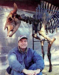
Couple has Bison Skeleton on Display at Courthouse
(By Joel Stottrup, Princeton Union-Eagle, Thursday, May 20, 1999)
What is described as a complete skeleton of an extinct, ancient bison that roamed the area 8,000 to 10,000 years ago in an area that at least covers part of Sherburne County, is on display at the Sherburne County Courthouse in Elk River.
The skeleton was assembled last winter by Tom, Sarah and Jordon Barthel, and Gail Wilkinson.
The bones were discovered by Tom Barthel’s granddaughter, Sami Barthel, and some of her cousins beneath a layer of peat on property owned by Tom Barthel along the Snake River in the Orrock area. It lies west of Sherburne National Wildlife Refuge.
The Barthel family named the skeleton Samuel as a takeoff on Sami’s name and it was exhibited for two months at the Becker library.
Wilkinson, who works at the library, said Samuel was so popular there that he is missed and patrons would like to have him back.
The skeletal assembly was accomplished by using hot glue and screws, and parts of the skeleton, such as the legs, can be detached for transporting.
Tom Barthel, in an information sheet on the history of the ancient bison, says marshy areas developed in parts of Sherburne County after glaciers retreated and dropped sand 12,000 years ago.
Throughout the Anoka Sand Plain, as this soil is called, notes Barthel, there are swampy and marshy areas with layers of peat up to six feet deep.
Barthel says the big bison likely sunk to their death in the peat and ended up in the sandy strata below the peat.
St. Cloud State University biology professor Dr. Stanley Lewis supervised numerous digs in Sherburne County that revealed a substantial number of bones and bone fragments, of which most were bison, said Barthel.
The thick bones helped keep them preserved so long in the peat and are in remarkably good condition. He theorizes that the bison from which the bones have been found could have been driven to what was then a low area by fire and then died in a single event. Or, they could have perished one by one over a span of hundreds of years.
Skeleton is from a bull bison
The skeleton is from a bull bison, has a 28-inch horn span, and is about six feet high at the thoracic vertebra, or where the hump belongs.
Barthel told the Union-Eagle he has lots of bones of the ancient bison that could be fitted together to make a “fair number” of other skeletons.
“We’re very gratified people are interested in this and were very excited to find them,” he said. “It’s nice to find a complete skeleton a few feet down.”
Wilkinson says digging into the peat to look for ancient bones on the Barthel property has become a pastime whenever the family gets together now.
PREHISTORIC COPPER SPEARHEAD FOUND
By Herb Murphy
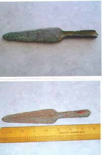
In the year 2000, while working as a lineman for Anoka Electric Cooperative of Ramsey, MN, Keith Schultz found a spearhead. He was digging a trench to connect electrical service to a new residence when he hit a hard object with the tip of his shovel. He unearthed what appeared to be a spearhead and then laid it aside while he finished his work. It had been lying about 4 feet down and 8 feet south of power pole #82682, which is about 700 feet east of the City of Baldwin line on Co HWY 28 in Spencer Brook Township.
Later that evening, when Keith cleaned the spearhead, he discovered that it was made of almost pure copper. It was 7 ¾ inches long and had a fluted end where a wooden shaft was likely attached. After doing some research on the Internet, he discovered that there was a prehistoric culture called the Old Copper Complex that once existed in this area. The Great Lakes Archaic Indians were among the first to make tools, weapons and jewelry from copper. Artifacts from this period date between 3000 and 6000 years ago.
For many years archaeologists have uncovered skeletons of prehistoric long horn bison, mammoths and giant beaver (up to 6 feet long) in the upper Great Lakes area including Canada, Isle Royal, Minnesota, Wisconsin and Michigan. Along with the skeletons they have found many tools and weapons were made of 99% pure copper.
For more information on The Old Copper Complex, please check out the following websites.
http://www.fox.uwc.edu/academics/depts/tpleger/oldcopper.html
http://www.mnus.edu/emuseum/archaeology/artifacts/oldcopper.html